
County Mayo
County Mayo, meaning “County of Plain of Yews”, after Mayo Abbey, is a county in the province of Connacht, located on the west coast of Ireland. It is bounded on the north and west by the Atlantic Ocean; to the south by County Galway; the east by County Roscommon; and the northeast by County Sligo. Mayo is the third-largest of Ireland’s 32 counties in area and 15th largest in terms of population. It is the second-largest of Connacht’s five counties in both size and population. The county town is Castlebar.
Mayo is located along the west coast of Ireland which is approximately 7,400km in length. There is a distinct geological difference between the west and the east of the county. The west consists largely of poor subsoils and is covered with large areas of extensive Atlantic blanket bog, whereas the east is largely a limestone landscape. Agricultural land is therefore more productive in the east than in the west. The highest point in Mayo (and Connacht) is Mweelrea, at 814 m (2,671 ft). The River Moy in the northeast of the county is renowned for its salmon fishing. Ireland’s largest island, Achill Island, lies off Mayo’s west coast and Mayo has Ireland’s highest cliffs at Croaghaun, Achill Island, while the Benwee Head cliffs in Kilcommon Erris drop almost perpendicularly 900 feet (270 m) into the Atlantic Ocean.
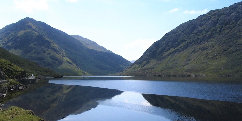
Doo Lough – ©Patrice78500, Public domain, via Wikimedia Commons
Birding County Mayo
The Annagh Marsh Reserve is an open pool system, with wet grasslands and the rare coastal machair ecosystem (flat sandy grasslands). Historically it was renowned for its breeding Red-necked Phalaropes and was the most southerly breeding location in the world for that species.
The Illaunmaistir Reserve is a small grass-domed island, rising to about 100m. It lies just off the north Mayo coast. During the summer months, looking across to the island from the near mainland, Puffins can be seen as they swirl around above their breeding burrows.
Knockmoyle Sheskin Nature Reserve is an extensive area of lowland blanket bog densely pool-studded and containing interesting flushes.
Oldhead Wood Nature Reserve is largely comprised of deciduous trees but has been modified by human usage over the years. It is situated 3 km. north-east of Louisburg. This small reserve lies on the east side of two knolls which form a promontory on the southern shore of Clew Bay. Due to its scenic location, it enjoys a very humid climate and this has resulted in a rich bryophyte flora. At the moment the Western Region of NPWS are drawing up a 10-year management plan for the Reserve which will hopefully enrich the old oak woodland status of the reserve.
Oldhead Wood Nature Reserve – ©MickReynolds CC BY-SA 4.0 via Wikimedia Commons
Owenboy Nature Reserve is an extensive bog of intermediate type lying in a broad basin. It contains a number of low domes resembling raised bogs and numerous flushes. It is utilised by Greenland White-fronted Geese and it has a rare species of moss.
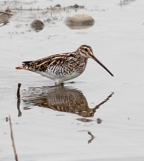
Termoncarragh Meadows is situated close to Termoncarragh Lough, which is just north of Annagh Marsh Reserve. The reserve extends to around 20 acres, split between semi-improved grassland and coastal pasture. It is an important area for a number of rare and important species. The grasslands not only attract pipits and larks, but also Corncrakes during the summer months. Snipe drum throughout the night. Grasshopper Warblers can be heard reeling evenings and early mornings. During the winter it is home to Barnacle Geese and large flocks of Golden Plover and both Rock Dove and Red-billed Chough.
-
Wikipedia
GNU Free Documentation License
https://en.wikipedia.org/wiki/County_Mayo
-
National Parks & Wildlife
National Parks and Wildlife, Lagduff More, Ballycroy, Westport
-
Number of bird species: 333
(As at March 2026)
-
Avibase
ChecklistThis checklist includes all bird species found in Mayo , based on the best information available at this time. It is based on a wide variety of sources that I collated over many years. I am pleased to offer these checklists as a service to birdwatchers. If you find any error, please do not hesitate to report them. -
eBird
PDF ChecklistThis checklist is generated with data from eBird (ebird.org), a global database of bird sightings from birders like you. If you enjoy this checklist, please consider contributing your sightings to eBird. It is 100% free to take part, and your observations will help support birders, researchers, and conservationists worldwide.

-
Birds of Ireland - A Field Guide
| By Jim Wilson | Gill Books | 2024 | Edition 2 | Paperback | 288 pages, 1600+ colour photos, colour distribution maps | ISBN: 9781804580721 Buy this book from NHBS.com -
Finding Birds in Ireland - The Complete Guide
| By Eric Dempsey & Michael O'Clery | Gill Books | 2014 | Edition 2 | Paperback | 389 pages, 300 colour photos, colour maps | ISBN: 9780717159253 Buy this book from NHBS.com -
Wild Guide - West of Ireland
| By Candida Frith-Macdonald & Daniel Start | Wild Things Publishing | 2025 | Paperback | 300 pages, 300 colour photos, 25 colour maps | ISBN: 9781910636602 Buy this book from NHBS.com
-
Birdwatch Mayo
WebsiteWelcome to the website of the Mayo Branch of Birdwatch Ireland. We run regular birdwatching events in County Mayo and new members are very welcome. -
Birdwatch Mayo
Twitter Website@BirdwatchMayo Bird watching group based in County Mayo, on the West coast of Ireland. New members always welcome.
-
NP Wild Nephin National Park
WebsiteSatellite ViewThis is one of the last intact active blanket bog systems in Ireland and Western Europe and is an important scientific and scenic feature of the National Park. The National Park is itself part of the Owenduff/Nephin Complex Special Area of Conservation (SAC) and Special Protection Area (SPA). -
NR Annagh Marsh
WebpageSatellite ViewThe Annagh Marsh Reserve is an open pool system set within wet grasslands associated with the rare coastal machair ecosystem (flat sandy grasslands). Historically it was renowned for its breeding Red-necked Phalaropes and was the most southerly breeding location in the world for that species. Unfortunately they ceased to breed in the early 1980’s. However they are making a comeback thanks to the ongoing management of the reserve, initiated by the EU LIFE project between 2002 and 2005. More typical breeding waders to be found are Lapwings and Snipe. Throughout the area Chough, Rock Dove and Twite are regularly seen, sometimes in numbers during the winter and dabbling ducks, Barnacle Geese and Whooper Swans occur in winter, commuting from Termoncarragh Lake. The reserve is also important for an array of rare insects which are found in very few other areas, such as the Great Yellow Bumblebee. -
NR Illaunmaistir
WebpageSatellite ViewThe Illaunmaistir Reserve is a small grass domed island, rising to about 100m, that lies just off the north Mayo coast. During the summer months, looking across to the island from the near mainland, Puffins can be seen as they swirl around above their breeding burrows. Under the cover of darkness, Storm Petrels return to their nests. Along the cliff tops breeding Twite may also be seen. Pods of dolphins or even a Minke Whale can sometimes be spotted offshore. -
NR Termoncarragh Lake
WebpageSatellite ViewThe Termoncarragh Lake Reserve is part of a large, shallow freshwater coastal lagoon set within the rare coastal machair ecosystem (sandy grasslands). The area is rich in wild flowers, insects and birds. Our reserve is part of the lake bed whilst the surrounding lands are privately owned. The whole area forms an extensive Special Protection Area and Special Area of Conservation. It is an important ecosystem which is renowned for its wintering waterfowl, including Whooper Swans and Barnacle Geese. The geese commute between the lake and the Inishkea Islands in winter. Breeding birds include Lapwing, Snipe, Sedge Warbler and Reed Bunting, as well as the secretive Corncrake and Water Rails.
-
eBird
SightingseBirding This Month