
County Kerry
County Kerry is a southwestern county of Ireland. Informally referred to as The Kingdom, it forms part of the Irish province of Munster, home to around 157,000 people. With an area of 4,746 km² (1,832 square miles), it is bordered by County Limerick to the east and County Cork to the south-east and Clare is across the Shannon Estuary. The county town is Tralee. One of Ireland’s most famous towns, Killarney, is located in Kerry. The Lakes of Killarney, an area of outstanding natural beauty, are located in Killarney National Park. The tip of the Dingle Peninsula is the most westerly point of both mainland Ireland and Europe. Likewise, Fenit, the port of Tralee, is the most westerly commercial shipping port in Europe.
Kerry faces the Atlantic Ocean and, typically for an Atlantic coastal region, features many peninsulas and inlets: principally the Dingle Peninsula, the Iveragh Peninsula, and the Beara Peninsula, shared with neighbouring County Cork. The county is bounded on the west by the Atlantic Ocean and on the north by the River Shannon. The Ring of Kerry on the Iveragh Peninsula is a popular route for tourists and cyclists. The pedestrian version is the scenic Kerry Way which follows ancient paths generally higher than that adopted by the Ring of Kerry.
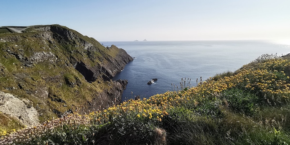
Iveragh Peninsula – ©Z thomas CC BY-SA 4.0 via Wikimedia Commons
Kerry contains two of the three highest mountains in Ireland, Carrauntoohil, part of the Macgillycuddy’s Reeks range and Mount Brandon, part of the Slieve Mish range.
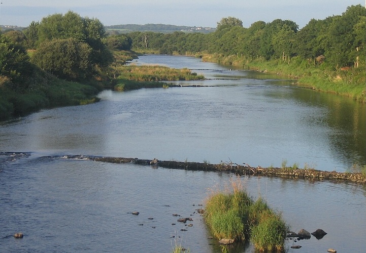
The Lakes of Killarney in the centre of the county are a scenic tourist attraction.
Just off Kerry’s coast are a number of islands, including the Blasket Islands, Valentia Island and the Skelligs. Skellig Michael is a World Heritage Site, famous for the medieval monastery clinging to the island’s cliffs. Kerry contains the extreme west point of Ireland Dunmore Head on the Dingle Peninsula, or including islands, Tearaght Island, part of the Blaskets. The most westerly inhabited area of Ireland is Dunquin, on the Dingle Peninsula. The River Feale, the River Laune and the Roughty River flow through Kerry, into the Atlantic.
The North Atlantic Current, part of the Gulf Stream, flows north by Kerry and the west coast of Ireland, resulting in milder temperatures than would otherwise be expected at the 52 North latitude. This means that subtropical plants such as the strawberry tree and tree ferns, not normally found in Northern Europe, thrive in the area. There are a number of gardens in the county, open to visitors.
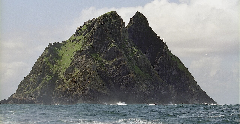
Great Skellig (Skellig Michael) – ©Jerzy Strzelecki CC BY-SA 3.0 via Wikimedia Commons
Because of the mountainous area and the prevailing south-westerly winds, Kerry is among the regions with the highest rainfall in Ireland. Due to its location, the area is the site of a weather reporting station on Valentia for many centuries. The Irish record for one-day rain-fall is 243.5 mm (9.59 in), recorded at Cloore Lake, in Kerry in 1993.
Birding County Kerry
Killarney National Park has an unforgettable combination of mountains, lakes, woodland and waterfalls and the last surviving indigenous herd of red deer in Ireland. The native oak and particularly Irelands largest yew woods are of national and international importance. 140 bird species have been seen in the park from Red-throated Divers to White-throated Dippers. The sheltered woodlands of Burnham Lagoon are also great for woodland birds, especially in May and June, when Spotted Flycatcher and Blackcap breed. The park is also known for the recent reintroduction of White-tailed Eagles.
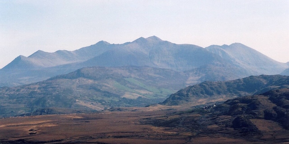
MacGillycuddy’s Reeks – ©Matpib CC BY-SA 3.0 via Wikimedia Commons
McGillicuddy Reeks, the highest peaks in Ireland, have Chough and Wheatear and breeding Ring Ousel and, in winter, there are Snow Buntings, albeit in small numbers. It is great for raptors with Peregrine and Merlin as well as a stronghold for Raven.
The north coast has a variety of estuary and coastal birds to be found along the shore of the Shannon from Beale Point to Tarber. Anywhere along the coast can be good birding, but the rocky headland of Slea Head overlooking the Atlantic Ocean has views of the most westerly point of Ireland, the Blasket Islands about 3 miles from the mainland. Great Blasket Island is good for seabirds in Summer and rare migrants have been known. Autum through to early spring for sea-watching and potential vagrants and a good chance of seeing Chough (Dunquin and Coumeenoole are also good Chough locations). Kerry Head is also a good sea-watching spot as is Coosgorm Rocks with occasional Shearwaters. To get up close to nesting seabirds try a boat trip out to Great Skellig for Puffin, Fulmar, Kittiwake, Guillemot and Razorbills, with almost 30,000 pairs of Gannets nesting on Little Skellig. Storm Petrels may well be seen from the boats.
The Blennerville area is particularly productive the mudflats near the windmill for a good variety of wildfowl and waders – Lapwing flocks can number a thousand birds. Barrow Harbour is a reliable spot for Spotted Redshank in winter and holds thousands of Brent Geese. Rough Point and the neighbouring beaches are the best place to see Purple Sandpipers and can have large numbers of Sanderling and Ringed Plovers. Sandy Bay is the place for divers and rarer grebes on the sea autumn through early spring as well as reliable Black Guillemot and Red-breasted Merganser as is Brandon Bay, which is also known for large Scoter flocks, as is Castlemaine Harbour. Gannets and Auks abound here at the right times. For breeding Black Guillemot try Dingle Harbour.
River Feale – ©Larsoner Public Domain via Wikimedia Commons
The large Cashen Estuary is most productive in autumn and winter for a variety of waders and wildfowl, including large numbers of Golden and a large Whooper Swan flock as well as variable numbers of Greenland White-fronted Geese. It is particularly good in Autumn for waders with always the chance of interesting vagrants. Carrahane Estuary is also good for Autumn waders close to high tide. Trabeg Estuary is particularly good for Kingfishers at its eastern end.
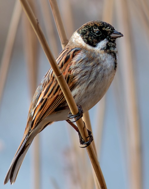
For freshwater species Lough Gill, a large freshwater lake and reedbed best viewed from the east side. It is good from late autumn to early spring for Whooper Swan, Scaup, Teal, Wigeon and other wildfowl. In summer, Reed Bunting and Sedge Warbler are common.
-
Wikipedia
GNU Free Documentation License
https://en.wikipedia.org/wiki/County_Kerry
-
Michael O'Clery & Jill Crosher
-
Number of bird species: 352
(As at March 2026)
-
Avibase
PDF ChecklistThis checklist includes all bird species found in Kerry , based on the best information available at this time. It is based on a wide variety of sources that I collated over many years. I am pleased to offer these checklists as a service to birdwatchers. If you find any error, please do not hesitate to report them. -
eBird
PDF ChecklistThis checklist is generated with data from eBird (ebird.org), a global database of bird sightings from birders like you. If you enjoy this checklist, please consider contributing your sightings to eBird. It is 100% free to take part, and your observations will help support birders, researchers, and conservationists worldwide.

-
Birds of Ireland - A Field Guide
| By Jim Wilson | Gill Books | 2024 | Edition 2 | Paperback | 288 pages, 1600+ colour photos, colour distribution maps | ISBN: 9781804580721 Buy this book from NHBS.com -
Finding Birds in Ireland - The Complete Guide
| By Eric Dempsey & Michael O'Clery | Gill Books | 2014 | Edition 2 | Paperback | 389 pages, 300 colour photos, colour maps | ISBN: 9780717159253 Buy this book from NHBS.com -
Wild Guide - West of Ireland
| (Travel Adventure Guide - Wild Atlantic Way, Donegal, Galway, Mayo, Clare, Cork & Kerry) | By Candida Frith-Macdonald & Daniel Start | Wild Things Publishing | 2025 | Paperback | 300 pages, 300 colour photos, 25 colour maps | ISBN: 9781910636602 Buy this book from NHBS.com
-
NP Killarney
WebsiteSatellite ViewIn all, 141 species of birds have been recorded in Killarney National Park to date. Some of these are resident, some are migrants, spending only part of the year here, whilst others occur as vagrants, appearing sporadically for such reasons as stormy weather conditions or unusually cold spells on the continent… -
NP Killarney National Park
WebpageSatellite ViewSouth and west of the town of Killarney in Co. Kerry is an expanse of rugged mountainous country. This includes the McGillycuddy’s Reeks, the highest mountain range in Ireland. At the foot of these mountains nestle the world famous lakes of Killarney. -
NR Little Skellig
WebpageSatellite ViewThe Little Skellig reserve is an iconic BirdWatch Ireland nature reserve. Isolated jagged pinnacles of rock rising up to 134 metres make for an impressive sight alongside its larger partner, Skellig Michael. Little Skellig is famed for its massive colony of some 35,000 pairs of Gannets, the largest breeding colony in Ireland and among the largest in the world, that make for an awe-inspiring sight from a boat. -
NR Puffin Island
WebpageSatellite ViewThe Puffin Island Reserve is a narrow steep-sided island rising to 145 m with spectacular cliffs which, as its name suggests, is home to breeding Puffins during the summer months. Thousands of birds can be seen as they swirl around above their breeding burrows. Under the cover of darkness the island comes alive with thousands of Manx Shearwaters returning to their nests. On the steep cliffs, Guillemots, Razorbills and Kittiwakes also breed.
-
Oriole Birding
Tour OperatorLast week Nick and myself decided to make a last-minute dash for the West coast of Ireland in the hope of connecting with some epic seawatching and the first trans-Atlantic crossing of American shorebirds of the autumn.
-
Sneem Hotel
AccomodationEnjoy the rest and relaxation of a luxury guest room overlooking Goldens Cove or natural countryside in our Kerry Hotel. We have the best self catering in Kerry, the best hotels with balconies in Ireland.
-
Kerry Birding
WebsiteIf you have bird news, photos or video of rare or interesting Kerry birds that you would like to see on this site, please e-mail or text us
-
Michael O'Clery - Kerry Birding
BLOG"In natural science the principles of truth ought to be confirmed by observations." (Linnaeus). "Though, preferably backed up by a series of high quality digital photos and video." (KerryBirding).