Niue

Niue is a self-governing island country in free association with New Zealand. It is situated in the South Pacific Ocean and is part of Polynesia, and predominantly inhabited by Polynesians. One of the world’s largest coral islands, Niue is commonly referred to as ‘The Rock’, which comes from the traditional name ‘Rock of Polynesia’. It is positioned inside a triangle drawn between Tonga, Samoa, and the Cook Islands. It is 2,400 kilometres (1,500 miles) northeast of New Zealand, and 600 kilometres (375 miles) northeast of Tonga. Niue’s land area is a little over 260 km2v (c.100 square miles) and its population around 1,700 people. The terrain of the island has two noticeable levels. The higher level is made up of a limestone cliff running along the coast, with a plateau in the centre of the island reaching approximately 60 metres (200 feet) above sea level. The lower level is a coastal terrace approximately 0.5 km (0.3 miles) wide and about 80-90 feet high, which slopes down and meets the sea in small cliffs. A coral reef surrounds the island, with the only major break in the reef being in the central western coast, close to the capital, Alofi.
There are three outlying coral reefs within the exclusive economic zone, with no land area: Beveridge Reef is a submerged atoll drying during low tide, it measures 9.5 km North-South by 7.5 km East-West, with a total area of 56 km², with no land area. The lagoon is 11 meters deep. Antiope Reef is a circular plateau approximately 400 meters in diameter, with a depth of at least 9.5 meters. Haran Reef (Harans Reef) is reported to break furiously. Albert Meyer Reef is almost km long and wide, with a depth of at least 3 meters, and is not officially claimed by Niue.

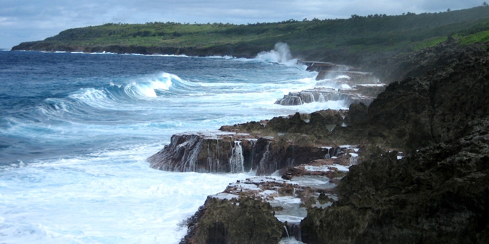
Coastline at Avatele – ©Flickr user fearlessRich CC BY 2.0 via Wikimedia Commons
Niue is one of the world’s largest coral islands. A notable feature of the island is the number of limestone caves found close to the coast. The island is roughly oval in shape (with a diameter of about 18 kilometres), with two large bays indenting the western coast (Alofi Bay in the centre and Avatele Bay in the south). Between these is the promontory of Halagigie Point. A small peninsula, TePā Point (or Blowhole Point), is located close to the settlement of Avatele in the southwest. Most of the island’s population resides close to the west coast, around the capital, and in the northwest.
The island has a tropical rainforest climate, with high temperatures and rainfall throughout the year. Although there are no true wet or dry seasons, there is a noticeably wetter stretch from October to May.
Birding Niue
Niue is attempting to pursue a policy of green growth. The Niue Island Organic Farmers Association is currently paving way to a Multilateral Environmental Agreement (MEA) committed to making Niue the world’s first fully organic nation by 2020. It has already become the first entire country to be designated an International Dark Sky Sanctuary. Niue aims to use 80% renewable energy by 2025 and has a number of solar energy installations. The country has declared its entire economic zone a marine park.

Limu Reef – ©Msdstefan at de.wikipedia CC BY-SA 2.0 DE via Wikimedia Commons
The island is home to approximately 60 native or pre-European plants, and approximately 160 naturalised flowering plant species. Compared to other Polynesian islands, Niue has sparse documentation for what plants were traditionally found on the island (almost no records are found between the documentation by James Cook’s crew in 1774, and Truman G. Yuncker’s botanical survey of the island in 1940).
The Huvalu Forest Conservation Area is a 5,400-hectare site on the eastern side of the island. It was established in 1992 and protects the largest area of primary forest in Niue. It has been designated an Important Bird Area (IBA) by BirdLife International because it supports populations of Crimson-crowned Fruit Doves, Blue-crowned Lorikeets, Polynesian Trillers and Polynesian Starlings.
-
Wikipedia
GNU Free Documentation License
https://en.wikipedia.org/wiki/Niue
-
Number of bird species: 58
(As at January 2025)
-
Avibase
PDF ChecklistThis checklist includes all bird species found in Niue , based on the best information available at this time. It is based on a wide variety of sources that I collated over many years. I am pleased to offer these checklists as a service to birdwatchers. If you find any error, please do not hesitate to report them. -
Wikipedia
Annotated ListThere are 57 species of birds that have been recorded on Niue, of which one has been introduced by humans. -
e Bird
PDF ChecklistThis checklist is generated with data from eBird (ebird.org), a global database of bird sightings from birders like you. If you enjoy this checklist, please consider contributing your sightings to eBird. It is 100% free to take part, and your observations will help support birders, researchers, and conservationists worldwide.
-
A Guide to the Birds of Fiji and Western Polynesia including American Samoa, Niue, Samoa, Tokelau, Tonga, Tuvalu and Wallis & Futuna
By Dick Watling | Dick Watling | 2004 | Paperback | 16 Full Colour Plates; Figures, Tables & Maps; 272 pages | Out of Print | ISBN: 9789829030047 Buy this book from NHBS.com
-
Niue Ocean Wide
Facebook PageThe NOW project, under Tofia Niue (NPO) in partnership with the Government of Niue, aims to develop and implement a management framework for Niue's EEZ to ensure long term sustainability of the ocean and its resources.
-
Huvalu Conservation Area
WebpageSatellite Viewhe Huvalu Forest Conservation Area and is situated on the eastern part of the island. The Conservation Area was established in 1992 and covers an area of approximately 54 square kilometres (5,400 ha) surrounding the largest area of primary forest in Niue. It also includes an area of reef platform about 15 to 20 metres from the high tide mark.
-
2019 [06 June] - Tim Barnard
ReportSpent an enjoyable week on Niue at the start of June. I'm slowly uploading data into eBird but here are a few notes for interest. No surviving endemics but a couple of endemic sub-species of Polynesian Triller and Polynesian Starling. We had planned to do a pelagic but a combination of huge swells, gusty winds and small boats put paid to that...
-
Niue - Secondary Area
WebpageBirdLife data zone

