
Bihar
Bihar is a state in Eastern India. It is the third largest state by population with around 130 million people. It is the 12th largest by area being over 94,000 km² (36,000 square miles), and the 14th largest by GDP. Bihar borders Uttar Pradesh to its west, Nepal to the north, the northern part of West Bengal to the east, and Jharkhand to the south. Bihar is split by the river Ganges, which flows from west to east fed by its northern tributaries originating in the Nepalese Himalayas, such as the Son, Budhi Gandak, Koshi, Chandan, Orhani and Falgu. The Himalayas greatly Bihar’s landforms, climate and hydrology. Bihar is mainly a vast stretch of very fertile flat land and only 7% of the land is forested. Close to 88% of the population lives in rural areas and the state has the highest percentage of young people.
Bihar lies completely in the Subtropical region of the Temperate Zone, and its climatic type is humid subtropical. The state is mildly cold in the winter (December and January), the lowest temperatures being around 5-10°C. It is hot in the summer (April to mid-June) with average highs around 35-40° C. The monsoon months (June, July, August and September) see good rainfall. October & November and February & March have a very pleasant climate.
Around 6,800 km² are in conservation with Valmiki National Park covering about 800 km2 of forest and its Tiger Reserve is ranked fourth in terms of the density of its tiger population. It has a diverse landscape and biodiversity in addition to sheltering protected carnivores. Vikramshila Gangetic Dolphin Sanctuary in Bhagalpur region is a reserve for the endangered South Asian river dolphin. Other species in Bihar include leopard, bear, hyena, bison, chital and barking deer. Crocodilians including gharials and muggers as well as Gangetic turtles can be found in the river systems. Karkatgarh Waterfall on Karmanasa River is a natural habitat of the crocodilians and has been turned into a Crocodile Conservation Reserve. Other notable wildlife sanctuaries include Kaimur Wildlife Sanctuary, Bhimbandh Wildlife Sanctuary and Gautam Buddha Wildlife Sanctuary.
Himalayan Foot Hills, Valmikinagar – ©Mywikieditbh CC BY-SA 4.0 via Wikimedia Commons
Birding Bihar
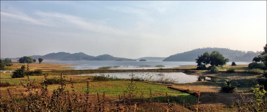
Many varieties of local and migratory bird species can be seen in natural wetland of Kanwar Lake Bird Sanctuary, Asia’s largest oxbow lake and only Ramsar site in Bihar, and other notable wetlands of Baraila lake, Kusheshwar Nath Lake, Udaypur lake.
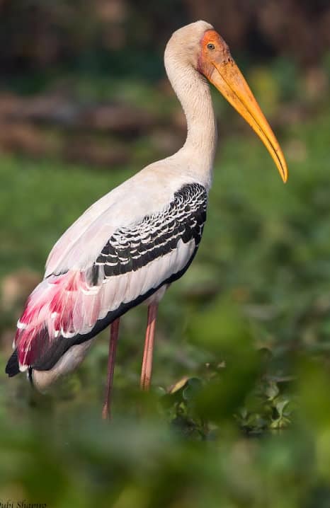
Forested areas preserved as habitat for tigers and other predators and big game co-incidentally benefit avian species too. Hillside forest is also good for some of the higher elevations species found further north such as Kalij Pheasant as well as the normal woodland species like barbets, woodpeckers and minivets etc. The great rivers and many wetlands on their floodplains help many wetland species including Painted Storks, waders and wildfowl. Uncultivated scrub harbours coucals and bee-eaters, finches and sunbirds, mynas and starlings etc.
Local culture has also helped greatly with some areas very protective of the birdlife such as storks in general and Greater Adjutant in particular, making this one of the best places in the world to see them.
Despite its high population the rural nature of most of the state, and its relatively less intensive farming makes it good for birdlife. Mango orchards are great habitat for parakeets, cuckoo-shrikes, orioles, treepies, fantails and more. Cultivated areas, with shade trees and ditches, subsistence crops and so forth are shared with a good variety of birds from shrikes, swallows and rollers to bulbuls, koels and warblers.
Most towns have many birds, albeit in less variety than the countryside. Bihar is a birding destination slightly off the normal birding routes but well worth visiting for its numbers and diversity as well as some very special birds.
-
Wikipedia
GNU Free Documentation License
http://en.wikipedia.org/wiki/Bihar
-
Number of bird species: 618
(As at April 2024)State Bird:- House Sparrow Passer domesticus
-
Avibase
PDF ChecklistThis checklist includes all bird species found in Bihar , based on the best information available at this time. It is based on a wide variety of sources that I collated over many years. I am pleased to offer these checklists as a service to birdwatchers. -
Bubo Birding
ChecklistThis checklist includes all species that have been reported in Bihar in eBird, but updated to IOC taxonomy, together with the likelihood of seeing each species for each month of the year.

-
Birds in Bihar (2-Volume Set)
| By Department of Environment and Forest, Bihar | Published by Department of Environment and Forest, Bihar | 2015 | Paperback | 353 pages, colour photos, colour maps | ISBN: Buy this book from NHBS.com
-
Bird Lovers of Bihar & Jharkhand
Facebook PageIt's a group for bird's lover, where one can share, cherish and exchange thier views, thoughts and information regarding birds. It's a plaform for beginner, -
Young Birders Club Darbhanga
Facebook PageThe benefits of membership in Young Birders Club extend well beyond getting outside on field trips. Club help increase awareness and appreciation of the natural world and in still a conservation ethic in its members. Club activities also build important life-skills such as peer mentoring, leadership, communication, community involvement, and more.
-
BS IBA Barela Jheel Salim Ali Bird Sanctuary
InformationSatellite ViewThe lake attracts many waterfowl in winter but is also home to around 150 resident bird species. -
BS IBA WII Nakti Dam & Nagi Dam
InformationSatellite ViewThe Nagi Dam (791 ha) and Nakti Dam (332 ha) are two sanctuaries so close to each other that they can be taken as one bird area. Nagi is c. 7 km from Jhagha in the district Jamui, and Nakti is a further c. 4 km from Nagi, occupying similar habitat. These notified sanctuaries are surrounded by rocky hillocks, formed by the damming of streams. Both these waterbodies are quite deep, with a clear water surface. These dams were built to supply water to local farms. There are cultivable lands adjacent to both the waterbodies. Indian Courser Cursorius coromandelicus, Indian Sandgrouse Pterocles exustus, Yellow-wattled Lapwing Vanellus malabaricus and Indian Robin Saxicoloides fulicata can be found in the drier areeas and in winter the dams can attract 20,000 waterfowl, -
BS Kanwar Lake
InformationSatellite ViewThe Kanwar Taal or Kabar Taal Lake located in Begusarai district of Bihar, India, is Asia's largest freshwater oxbow lake. It is approximately three times the size of the Bharatpur Sanctuary. -
NP Betla
InformationSatellite ViewBetla National Park is a national park located on the Chhota Nagpur Plateau in the Latehar district of Jharkhand, India. The park hosts a wide variety of wildlife. Birds include the hornbill, peafowl, red jungle fowl, black partridge, white-necked stork, black ibis, swamp grey, quail, pied hornbill, wagtail, harial, dove, drongo, crested serpent-eagle, forest owlet, papeeha, and other birds usually found in dry deciduous forests. The Kamaldah lake attracts several varieties of water birds including the common whistling, cotton teal, knob-billed duck, snipe and geese. -
NP WS TR Valmiki
InformationSatellite ViewAt present 241 bird species have been reported from VTR. Some of the interesting birds of VTR are Nepal kaleej pheasant, three-toed quail, flycatcher, grey shrike, green willow warbler, tree pipit, white eye, green barbet, waders, ibises, storks, pitta, plovers, snipes, pied hornbill, emerald dove. Mammals include Tiger, Rhinoceros, Black bear, Leopard, Wild dog, wild buffalo, wild boar etc. There are several species of deer and antelopes found in VTR which are barking deer, spotted deer, Hog deer, Shambhar, Blue bull. In places the park shares a border with Chitwan NP, Nepal. -
WS Bhimbandh
InformationSatellite ViewBhimbandh Wildlife Sanctuary is a wildlife sanctuary in Bihar in the south west of Munger district near Jamui district. Birds such as the lesser white-fronted goose, ferruginous duck, Baer's pochard duck and lesser adjutant, greater adjutant, black-necked stork, and Asian openbill stork migrate from Central Asia to the park during winter. -
WS Gautam Budha
InformationSatellite ViewGautam Budha Wildlife Sanctuary (also spelled Gautam Buddha) is a wildlife sanctuary located in Gaya district of Bihar state and Koderma district of Jharkhand state in east-central India. The refuge covers portions of the Lower Gangetic Plains moist deciduous forests and Chota Nagpur dry deciduous forests ecoregions. Fauna include tigers, leopards, wolves, sloth bears, chitals, chinkaras, and many species of birds. -
WS Hazaribahg Sanctuary
InformationSatellite ViewAn abundance of wild animals is a very pleasant sight. Wild bear, Nilgai, Chital and Kakar can be seen at dusk and dawn, gambolling and enjoying themselves in the waters of the lake. The tiger and panther, exclusive attractions at this sanctuary demand extreme patience from the viewer. Hazaribagh perhaps holds more Sambhars than any other area of comparable size. The 1970 census has established the presence of 14 tigers, 25 Panthers and 400 Sambars. -
WS Kaimur
InformationSatellite ViewKaimur Wildlife Sanctuary is located in Kaimur District of Bihar, near the town of Bhabhua. It is the largest sanctuary in the state and occupies an area of about 1342 km2. -
WS TR Palamau
InformationSatellite ViewThere are good motorable roads inside the park that offer the motorists a close view of the wild in the dense forests. Providing excellent opportunities for observing the animals, without causing any disturbance, There are two towers and a tree top tower. There are around 150 bird species in the park as well as Tigers, elephants leopard and may other mammals.
-
Hotel Ananda
eMail+ 919798536178/ +919234247822
-
Ornithology & Ophthalmology in Rural Bihar, India
Fatbirder Article‘The Adjutant half turned his head, sheered a little in the direction of the voice, and landed stiffly on the sand-bar below the bridge...