
Republic of the Sudan
Sudan is a country in Northeast Africa. It borders the Central African Republic to the southwest, Chad to the west, Libya to the northwest, Egypt to the north, the Red Sea to the east, Eritrea and Ethiopia to the southeast, and South Sudan to the south. Sudan has a population of over 51 million people and occupies an area of over 1,886,000 km2 (over 728,000 square miles), making it Africa’s third-largest country by area and the third-largest by area in the Arab League. It was the largest country by area in Africa and the Arab League until the secession of South Sudan in 2011; since then both titles have been held by Algeria. Sudan’s capital and most populous city is Khartoum with around 6.75 million inhabitants.
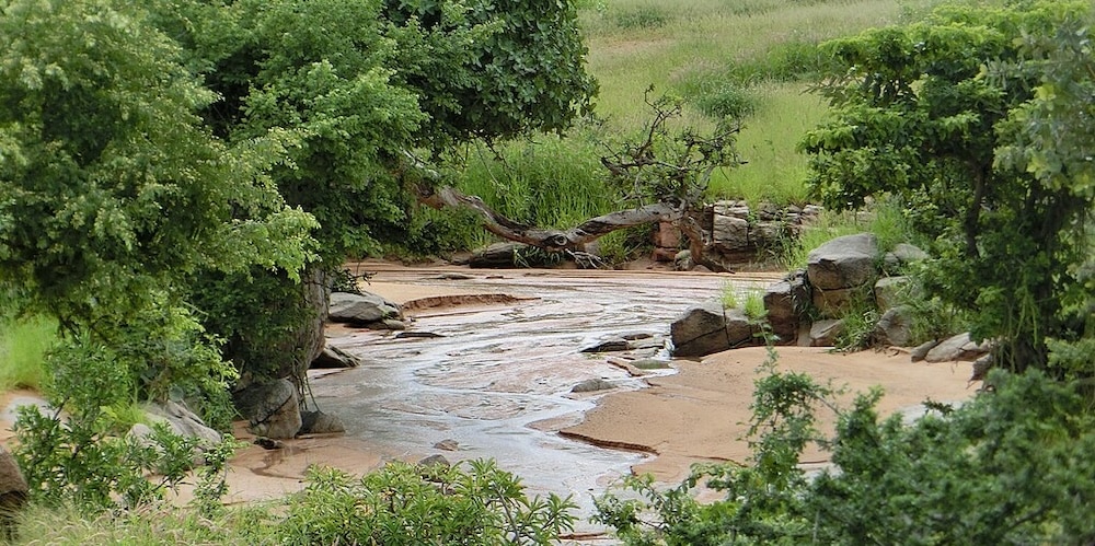
The terrain is generally flat plains, broken by several mountain ranges. In the west, the Deriba Caldera at 9,980 feet, located in the Marrah Mountains, is the highest point in Sudan. In the east are the Red Sea Hills. The Blue Nile and White Nile rivers meet in Khartoum to form the Nile, which flows northwards through Egypt to the Mediterranean Sea. The Blue Nile’s course through Sudan is nearly 800 km (497 miles) long and is joined by the Dinder and Rahad Rivers between Sennar and Khartoum. The White Nile within Sudan has no significant tributaries. There are several dams on the Blue and White Niles. Among them are the Sennar and Roseires Dams on the Blue Nile, and the Jebel Aulia Dam on the White Nile. There is also Lake Nubia on the Sudanese-Egyptian border.
Rich mineral resources are available in Sudan including asbestos, chromite, cobalt, copper, gold, granite, gypsum, iron, kaolin, lead, manganese, mica, natural gas, nickel, petroleum, silver, tin, uranium and zinc.
Dugu Area South Darfur – ©FUDOL YOUSUF AHMED HAMID CC BY-SA 4.0 via Wikimedia Commons
The amount of rainfall increases towards the south. The central and the northern part have extremely dry, semi-desert areas such as the Nubian Desert to the northeast and the Bayuda Desert to the east; in the south, there are grasslands and tropical savanna. Sudan’s rainy season lasts for about four months (June to September) in the north, and up to six months (May to October) in the south. The dry regions are plagued by sandstorms, known as haboob, which can completely block out the sun. In the northern and western semi-desert areas, people rely on scarce rainfall for basic agriculture and many are nomadic, travelling with their herds of sheep and camels. Nearer the River Nile, there are well-irrigated farms growing cash crops. The sunshine duration is very high all over the country, but especially in deserts where it can soar to over 4,000 hours per year.
Desertification is a serious problem in Sudan. There is also concern over soil erosion. Agricultural expansion, both public and private, has proceeded without conservation measures. The consequences have manifested themselves in the form of deforestation, soil desiccation, and the lowering of soil fertility and the water table.
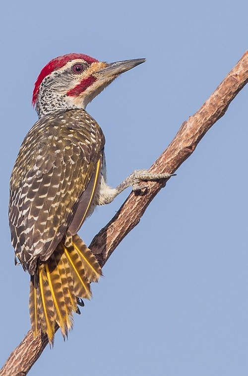
Birding Sudan
A variety of climate types in Sudan results in a wide range of habitats and the range of wildlife is diverse. Some 287 species of mammal have been recorded in the country and some 634 species of birds, including Kordofan sparrow Passer cordofanicus, which is endemic to Sudan and South Sudan (although it is in only a small area in the north of South Sudan and may be present in border areas of Chad).
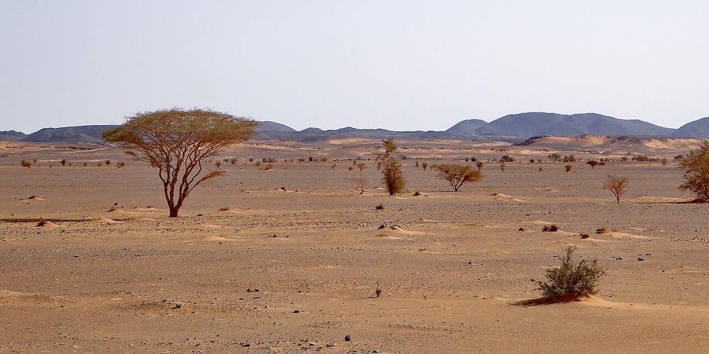
Nubian Desert – ©Hans Birger Nilsen CC BY-SA 2.0 via Wikimedia Commons
The northern part of the country is largely desert with very little vegetation except beside watercourses. In more central parts, the semidesert receives rather more precipitation and supports Acacia scrub and various grasses. With the increased rainfall further south this merges into savannah with grasses, thorny trees and larger baobab trees. These are dominated by Acacia trees, including the Sudan gum Acacia senegal which yields gum arabic, historically one of the mainstays of the country’s export trade. The Nile basin in the south receives more rainfall, and the grass is lush, providing grazing for herds of cattle. There are also patches of woodland here. A characteristic tree which grows in woodland and beside seasonal water-courses in the Marrah Mountains is the winter thorn Faidherbia albida. Cattle stand in its shade in the dry season eating shed leaves and fruits, and sorghum crops do well underneath it in the rainy season.
Most of the 287 or so species of mammal found in Sudan are small and nocturnal, being rodents, bats and insectivores. Elephant shrews also occur, and among the larger mammals are crested porcupine and rock hyrax. Big cats found in Sudan include lions, leopards and cheetahs. There are many species of antelope as well as giraffes, rhinoceroses and elephants. Monkeys are found in forested areas.
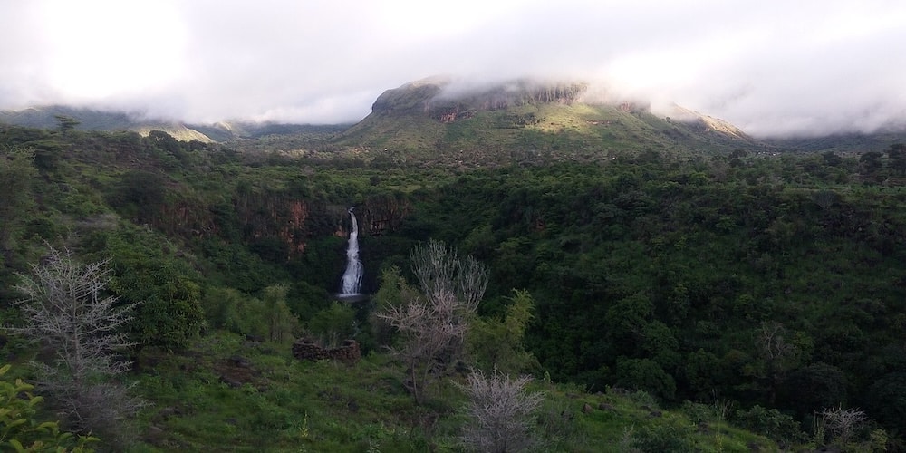
Marrah Mountains – ©Mohamed Siddig Abdelaziz CC BY-SA 4.0 via Wikimedia Commons
Reptiles are abundant but mostly small and inconspicuous. Snakes are numerous and include the African rock python, black mamba, Egyptian cobra, forest cobra, black-necked spitting cobra, boomslang and puff adder. Crocodiles are found near the Nile and other water bodies and there are many species of lizard, the largest being the Nile monitor. The African spurred tortoise and the leopard tortoise occur in arid areas and several aquatic species of terrapin, such as the African helmeted turtle, occur in swamps and marshes.
Among several protected areas in Sudan are Radom National Park in South Darfur, in the southwest of the country, and Dinder National Park in the southeast, both of which are UNESCO biosphere reserves. There are also a number of game reserves. The Suakin Archipelago National Park is a cluster of islands off the coast in the Red Sea and is a marine protected area of 579 square miles. These islets are fringed by coral reefs, being visited by four species of turtle and home to five species of breeding bird.
-
Wikipedia
https://en.wikipedia.org/wiki/Sudan
-
Number of bird species: 640
(As at February 2025)
National Bird: Secretarybird Sagittarius serpentarius
-
Avibase
PDF ChecklistThis checklist includes all bird species found in Sudan , based on the best information available at this time. It is based on a wide variety of sources that I collated over many years. I am pleased to offer these checklists as a service to birdwatchers. If you find any error, please do not hesitate to report them. -
E-Bird
PDF ChecklistThis checklist is generated with data from eBird (ebird.org), a global database of bird sightings from birders like you. If you enjoy this checklist, please consider contributing your sightings to eBird. It is 100% free to take part, and your observations will help support birders, researchers, and conservationists worldwide. -
Wikipedia
Annotated ListThis is a list of the bird species recorded in Sudan. The avifauna of Sudan include a total of 633 species.

-
Birds of the Horn of Africa: Ethiopia, Eritrea, Djibouti, Somalia and Socotra
| By Nigel Redman, Terry Stevenson & John Fanshawe | Christopher Helm | 2011 | Paperback | 512 pages, 213 colour plates, 1000+ colour distribution maps, colour & b/w maps | ISBN: 9781408157350 Buy this book from NHBS.com

Birds of Africa
Apple iOS | AndroidAbout this App Birds of Africa is an identification guide which in time will cover all the birds and countries in Africa. This version includes more than 1,800 species and has all West African and 8 East African countries. Birds of Africa – an identification guide which in time will cover all the birds and countries in Africa. The latest version of this app is available to download for free from the App Store or Google Play.Organisations-
African Bird Club
WebsiteThere is plenty to attract the keen birdwatcher to Sudan were it not for major concerns over safety. One can only hope that the situation improves sufficiently to allow greater travel in this country. Sudan is not a country where you will see the huge range of species on offer in East Africa but the Nile which flows through the capital Khartoum is a major migration corridor and birdwatching in this area will provide a good range of species and some surprises -
Birding Sudan
Facebook GroupToday marks 15 years of Birding Sudan! Thank you all for helping keep this community strong. -
Sudanese Bird Watcher Club
Webpage -
Sudanese wildlife society
Facebook Page
Reserves-
*List of protected areas of Sudan
InformationSatellite ViewInteractive list of National Parks, Wildlife Sanctuaries etc. -
BR NP Dinder
InformationSatellite ViewDinder National Park, park, eastern Sudan. The park lies in the clayish flood plain of the Nahr (river) ad-Dindar and Nahr ar-Rahad, at an elevation of 2,300 to 2,600 ft (700 to 800 m). Established in 1935, it covers an area of 2,750 sq mi (7,123 sq km). Vegetation in the park consists of thornbush savannah in the north and woodland in the south; along the riverbanks there are palm or gallery forests and swampy areas… -
BS Lake Kundi Bird Sanctuary
InformationSatellite ViewOf the avifauna, 5000-7000 Sudan crowned crane have been reported.[7] Other bird life includes yellow-billed stork, Abdim's stork, African sacred ibis, Arabian bustard, African collared dove, golden nightjar, red-throated bee-eater, yellow-billed shrike, piapiac, red-pate cisticola, foxy cisticola, cricket longtail, Senegal eremomela, chestnut-bellied starling, black scrub-robin, chestnut-crowned sparrow-weaver, bush petronia, black-rumped waxbil -
IBAs
WebsiteSatellite ViewThe enormous range of latitudes supports portions of 6 biomes: Saharan-Sindian in the north; Sahel; much of the south is within Sudan-Guinea Savanna; Guinea-Congo Forests in the south-west; Somali-Masai in the south-east; the southern mountains lie within the Afrotropical Highlands biome. Inland wetlands dominated by the Sudd are significant for large numbers of waterbirds and some of Sudan -
NP Radom National Park
InformationSatellite ViewThe Park is 1,250,970 hectares (3,091,200 acres) in size. The Adda and Umblasha Rivers form the park’s northern and southern boundaries. Contiguous to Radom is the Andre Felix National Park of the Central African Republic.[4] Established as a park, it was designated in 1979 as a member of the World Network of Biosphere Reserves.
Sightings, News & Forums-
eBird
SightingseBirding This Month
Trip Reports-
2006 [01 January] - Ola Elleström
Report PDF…The number of species was relatively few but I had a nice flock of Sudan Golden Sparrows close to the Mogran Family Park and a White-browed Coucal in some dense thickets close to the hotel…
-
Fatbirder - linking birders worldwide...
Skip to content