
Libya
Libya is a country in the Maghreb region of North Africa. It borders the Mediterranean Sea to the north, Egypt to the east, Sudan to the southeast, Chad to the south, Niger to the southwest, Algeria to the west, and Tunisia to the northwest, as well as maritime borders with Greece, Italy and Malta to the north. At 1,770 kilometres, Libya’s coastline is the longest of any African country bordering the Mediterranean. The portion of the Mediterranean Sea north of Libya is often called the Libyan Sea. Libya comprises three historical regions: Tripolitania, Fezzan, and Cyrenaica. With an area of almost 1.8 million km2 (700,000 square miles), it is the fourth-largest country in Africa and the Arab world, and the 16th-largest in the world. Libya claims 32,000 square kilometres of southeastern Algeria, south of the Libyan town of Ghat. The country’s official religion is Islam, with 96.6% of the Libyan population being Sunni Muslims. The official language of Libya is Arabic, with vernacular Libyan Arabic being spoken most widely. The majority of Libya’s population is Arab. The largest city and capital, Tripoli, is located in northwestern Libya and contains over 1.2 million of Libya’s 7.5 million people.
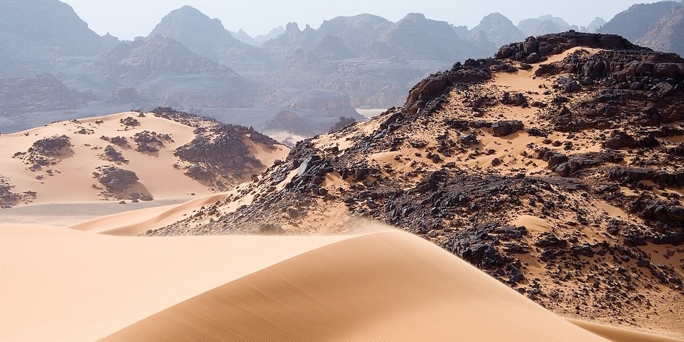
In the Libyan desert here are a few scattered uninhabited small oases, usually linked to the major depressions, where water can be found by digging to a few feet in depth. In the west there is a widely dispersed group of oases in unconnected shallow depressions, the Kufra group, consisting of Tazerbo, Rebianae and Kufra. Aside from the escarpments, the general flatness is only interrupted by a series of plateaus and massifs near the centre of the Libyan Desert, around the convergence of the Egyptian-Sudanese-Libyan borders.
Slightly further to the south are the massifs of Arkenu, Uweinat, and Kissu. These granite mountains are ancient, having formed long before the sandstones surrounding them. Arkenu and Western Uweinat are ring complexes very similar to those in the Aïr Mountains. Eastern Uweinat (the highest point in the Libyan Desert) is a raised sandstone plateau adjacent to the granite part further west.
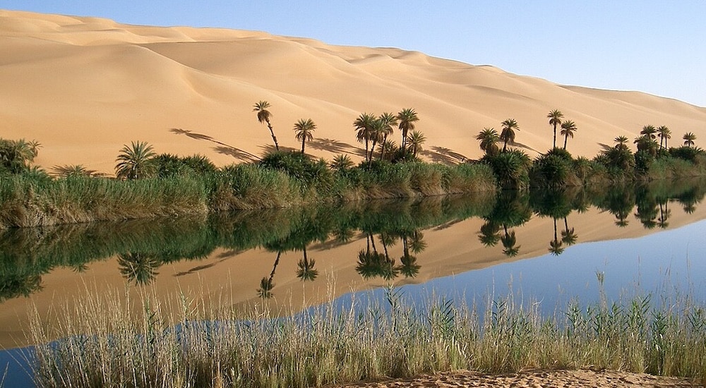
Lake Oum el Ma southwest Libya – ©Sfivat, Public domain, via Wikimedia Commons
The plain to the north of Uweinat is dotted with eroded volcanic features. With the discovery of oil in the 1950s also came the discovery of a massive aquifer underneath much of Libya. The Great Man-Made River is the world’s largest irrigation project. The project utilises a pipeline system that pumps fossil water from the Nubian Sandstone Aquifer System from down south in Libya to cities in the populous Libyan northern Mediterranean coast including Tripoli and Benghazi. The water provides 70% of all freshwater used in Libya.
The climate is mostly extremely dry and desert-like in nature. However, the northern regions enjoy a milder Mediterranean climate. The temperature in the Libyan Desert can be extreme; in 1922, the town of Aziziya, which is located southwest of Tripoli, recorded an air temperature of 58 °C, considered to be a world record.
Six eco-regions lie within Libya’s borders: Saharan halophytics, Mediterranean dry woodlands and steppe, Mediterranean woodlands and forests, North Saharan steppe and woodlands, Tibesti-Jebel Uweinat montane xeric woodlands, and West Saharan montane xeric woodlands.
Before the fall of Gaddafi even hunting rifles were forbidden. But since 2011, poaching has been carried out with weapons of war and sophisticated vehicles in which one can find up to 200 gazelle heads killed by militiamen who hunt to pass the time. We are also witnessing the emergence of hunters with no connection to the tribes that traditionally practice hunting. They shoot everything they find, even during the breeding season. More than 500,000 birds are killed in this way each year, when protected areas have been seized by tribal chiefs who have appropriated them.
Birding Libya
Libya is a country located in North Africa. Bordering the Mediterranean Sea to the north, Egypt to the east, Sudan to the southeast, Chad and Niger to the south, and Algeria and Tunisia to the west. With an area of almost 1.8 million km2 (700,000 square miles), 90% of which is desert, Libya is the fourth largest country in Africa by area, and the 17th largest in the world. The capital, Tripoli, is home to 1.7 million of Libya’s 5.7 million people. The three traditional parts of the country are Tripolitania, the Fezzan and Cyrenaica. The climate is mostly dry and desert like in nature. However, the northern regions enjoy a milder Mediterranean climate.
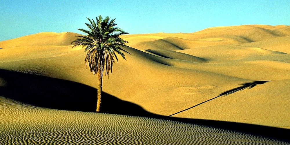
Saharan Date Palm – ©Victor Korniyenko CC BY-SA 3.0 via Wikimedia Commons
Libya can be conveniently divided into five zones for the purpose of characterising its birds and their habitats:
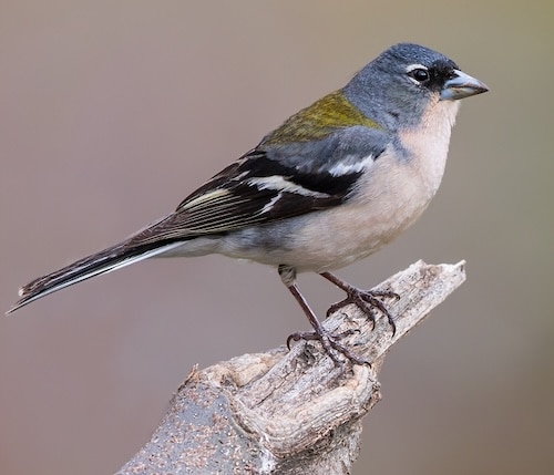
Western coastal zone (part of Tripolitania): This is centred around Tripoli. It is Mediterranean in climate with hot dry summers and warm wet winters. It is home to many breeding birds but is particularly interesting as a winter destination for many and varied European migrants. Rainfall is between 100 mm and 400 mm. Tripoli itself receives 271 mm. There is a wide variety of habitat. The most common is a mixture of garrigue and planted exotic species such as eucalyptus which unfortunately impoverish the landscape. This grades to semi desert as you go inland. But there are greener areas with wadis, cultivated land and grasslands. These are particularly found between Tripoli and Misratah. And in the far west near Tunisia and also south east of Misratah there are coastal salt marshes and lagoons. The salt marshes south east of Misratah can be very large. The low rise, low density nature of Tripoli gives it a feel of a collection of country towns. The birds think so too. Normally rural birds such as Kestrels, Barn Owls, Hoopoes and Spanish Sparrows are quite common sights alongside Pigeons and Laughing Doves.
While this coastal zone and that around Benghazi are climatically the most similar to southern European countries, the make-up of breeding birds is significantly different from them. There are more types of Wheatears and Larks. However, there is only one breeding bunting (House Bunting), less breeding finch species (only Chaffinch, Linnet, Goldfinch, Trumpeter Finch and Serin) and fewer non-Sylvia Warblers. Most obviously there is only one member of the crow family present- the Common Raven. On the other hand, there are some exotic breeders including Scrub Warbler scotocerca inquieta and Pallid Swifts. Little Owls, Barn Owls and Eagle Owls are also relatively common. There is no shortage of rodent food.
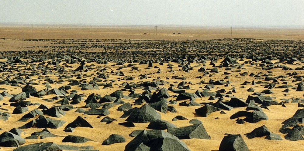
Basalt rocks in the desert – ©calind CC BY-SA 3.0 via Wikimedia Commons
The western Libyan coast is the last tract of land with food and shelter north of the Sahara for many birds. Some stop over for a day or two before or after flying over the Sahara. Many stay the winter. Huge numbers of birds such as European Bee-eaters and Honey Buzzards can be seen migrating. In the winter, huge flocks of Common Starlings and Skylarks roam the coast. Chiffchaffs, Stonechats and White Wagtails are three of the most commonly seen wintering species. The wetlands are wintering places for Flamingo and in some places Glossy Ibis and occasionally Common Cranes. Tens or even hundreds of Curlew visit Farwa near the border with Tunisia.
Jebel Nafusa (the other part of Tripolitania): The hill range south of Tripoli is called Jebel Nefusa. The north facing side and eastern plateau has rainfall which may also reach 400 mm. The southern facing side and western plateau are drier with their own distinct character. The north east side is centred on Ghayan (380 mm rain per annum). There are three man made dams and reservoirs in this area which add to the habitat variety. These are especially interesting for waders and water birds such as Herons, Egrets and in winter some ducks especially Shovelers. Winter waders include Black Winged Stilts. Away from the dams, Barbary Partridge, Fulvous Babblers, Black Wheatears and Red-rumped Wheatears, Crested and Thekla Larks as well as Trumpeter Finches all breed. House Buntings are very common in all the towns and villages. In the drier south and east, Crested and Thekla larks are less common, but the lark density is probably just as high because Hoopoe Larks, Desert Larks and Bar-tailed Larks breed. White-crowned Wheatears are relatively more common and Mourning Wheatears can be seen in winter. Groups of Brown-necked Ravens are easily seen. As in much of Libya many migratory flocks go unnoticed. However, Harriers in particular are seen.
Eastern Libyan coast and islands (part of Cyrenaica): The coast from Ajdabiya (annual rainfall is 140 mm) through Benghazi east to the Egyptian border like that of Tripoli has a Mediterranean climate. It has a similar mix of habitats, but its bird population is sufficiently different from the western coast for it to be considered separately. The island of Geziret Garah in the Gulf of Surt, which is very important for birds, is included here. This coast is slightly greener than around Tripoli. The breeding birds reflect the subtle change. For example, most larks are the same, there are no Desert Larks but there are Calandra Larks. There is also one breeding colony of White Storks. Geiret Garah is internationally significant because 90% of the Mediterranean’s Little Crested Terns breed there.
Acacus – ©Luca Galuzzi CC BY-SA 2.5 via Wikimedia Commons
Jebel Akhdar (the other part of Cyrenaica): This is the name of the highland area north and east of Benghazi. Here the maximum rainfall is over 600 mm. Much of this is a protected area. It has some natural woodland as well as Maquis and agricultural land. Like the area around Tripoli it is home to many breeding birds and is interesting as a winter destination for a different mix of European migrants. Common residents include Chaffinches, Linnets and Serins. There are Blue Tits, which are found nowhere else in Libya. Other breeders include Lesser Kestrels and Golden Eagles.
The Sahara (also called Fezzan): This makes up most of the rest of the country which is more than 90% of the land mass. The Libyan Desert is one of the most arid places on earth. In places, decades may pass without rain, and even in the highlands, rainfall happens erratically, once every 5 to 10 years. Natural hazards come in the form of hot, dry, dust-laden sirocco (known in Libya as the gibli). This is a southern wind blowing from one to four days in spring and autumn this creates dust storms and sandstorms. It not only effects desert areas, but reaches the coastal areas too. There are massive aquifers underneath much of the country. The water in this aquifer pre-dates the last ice ages and the Sahara Desert itself. There are a few places where this water table reaches the surface and produces oases or even lakes. Around the oases settlements invariably exist. The biggest are at Sebha (central Libya), Ghat (southwest Libya) and Kufra (eastern Libya).
The three largest lake concentrations are at Waw Al Namus, the Germa lakes and the Zallaf. Many migrants use these lakes as stopovers and there are a surprisingly large number of breeding water birds as well as resident desert species. There are also a few large man-made highly irrigated green projects in the middle of the desert. There are several types of birds which tolerate the Sahara, provide they have some access to water. The ‘truest’ desert birds are White-crowned Wheatear, Desert Wheatear, Desert Lark, Bar-tailed Lark, Hoopoe Lark, Spotted Sandgrouse, Crowned Sandgrouse, Trumpeter Finch and Brown-necked Ravens.
Many millions of migrants fly over the desert. The ones most commonly seen at the lakes and oases are Barn Swallows and Yellow Wagtails as they are active in the day. One very interesting phenomenon is the green crop circles produced by massive irrigation as part of the Government’s ‘greening the desert’ programme. Many of the circles are fodder like clover as well as hay. There are also palm plantations and citrus and olive groves. The two biggest concentrations of these circles are south of Kufra (eastern Libya) and south of the Germa Lakes (south western Libya). Recent research has shown the green oases attract very large numbers of wintering Storks, Egrets, Herons and Raptors, which might have previously been expected to winter south of the Sahara.
-
(The Late) Rob Tovey
Libya
http://www.birdingforalark.blogspot.co.uk
-
Number of bird species: 363
(As at February 2025)
-
Avibase
PDF ChecklistThis checklist includes all bird species found in Libya , based on the best information available at this time. It is based on a wide variety of sources that I collated over many years. I am pleased to offer these checklists as a service to birdwatchers. If you find any error, please do not hesitate to report them. -
E-Bird
PDF ChecklistThis checklist is generated with data from eBird (ebird.org), a global database of bird sightings from birders like you. If you enjoy this checklist, please consider contributing your sightings to eBird. It is 100% free to take part, and your observations will help support birders, researchers, and conservationists worldwide. -
Wikipedia
Annotated ListThis is a list of the bird species recorded in Libya. The avifauna of Libya include a total of 360 species. Two species listed are extirpated in Libya.

-
Birds of Europe, North Africa, and the Middle East - A Photographic Guide
| By Frédéric Jiguet & Aurélien Audevard | Princeton University Press | 2027 | Paperback | 447 pages, 2200 colour photos, colour distribution maps | ISBN: 9780691172439 Buy this book from NHBS.com -
Birds of Libya - Oiseaux de Libye
| By Paul Isenmann, Jens Hering, Stefan Brehme, Mohamed Essghaier, Khaled Etayeb, Essam Bourass & Hichem Azafzaf | Societé d'Etudes Ornithologiques de France | 2016 | Paperback | 302 pages, colour photos, colour distribution maps | Text French & English | ISBN: 9782916802046 Buy this book from NHBS.com
-
BirdLife
WebpageData on birds and IBAs etc
-
African Bird Club
WebpageWith direct flights from many European capitals and an improving political situation, Libya may offer opportunities for the enterprising birder. The most recent review of the birds of Libya is that of Bundy (1976) - see reference (i). He listed 317 species of which 92 were known to breed -
BirdWatch Libya
Facebook page -
Libya Wildlife Trust
WebsiteIUCN MEMBER Libyan Wildlife Trust Libyan Wildlife Trust is an environmental NGO, November 09 2011 was founded by a group of nature lovers and wildlife defenders.
-
*Protected areas of Libya
InformationSatellite View -
IBAs
WebsiteSatellite ViewNo species of restricted range are known but there are a number of species which are restricted to two particular biomes. The Mediterranean North Africa biome extends in a narrow strip along the Libyan coast and holds 12 of 17 species restricted to this biome. The Sahara-Sindian biome covers the rest of the country and holds 14 of the 22 species of this biome. Important breeding colonies of terns are found along the coast and a number of oases in the southern desert are important for migrants -
NP Algharabolli National Park
InformationSatellite ViewIt covers an area of 8,000 hectares. It has been designated an Important Bird Area (IBA) by BirdLife International because it supports significant populations of Barbary partridges, and Sardinian and speckled warblers. -
NP El-Kouf
InformationSatellite ViewEl Kouf is located along Libya's northeastern Mediterranean coastline and has both marine and terrestrial biodiversity. The national park lies within the Jabal al Akhdar IBA. Birds recorded from the park include golden eagles, Egyptian vulture, Barbary partridges, common quails, great bustard, Houbara bustards, black storks, white storks and sandgrouse, as well as herons, ducks and waders. Also noted are greater flamingos on the beaches and green peafowl introduced also many birds of prey. -
NR Benghazi Reserve
InformationSatellite ViewThe reserve is famous for migratory waterbirds, and includes a stretch of beach dunes and salt marshes. In addition to many lakes -
WII Ain Elshakika Wetland
InformationSatellite ViewAin Elshakika Wetland is a Ramsar-protected wetland of Libya. It was established in 2000, and covers an area of 33 hectares (82 acres) -
WII Ain Elzarga Wetland
InformationSatellite ViewThe sebkha, with mudflats and salt marsh community, is surrounded by dunes from east to west and rocky hills to the south and east. The site is one of the most important wetlands in the area of the El Kouf National Park for migratory waterbirds...
-
eBird
SightingseBirding This Month
-
2008 [01 January] - Mark Easterbrook
Report…A visit to the Arch of Marcus Aurelius in Tripoli started the day followed by visits to the museum and the souk. Southern Grey Shrike was a surprisingly common bird in the centre of Tripoli and later a walk along the harbour road produced a Common Sandpiper, Kingfisher, several Baltic Gulls, 2 Audouin's Gulls and a Pallid Swift drifted over the city. -
2010 [02 February] - Rob Tovey
PDF Report...Highlights included not one but two separate encounters with both Cream-coloured Courser and with Moussier's Redstart...
-
North Africa Birds
BLOG -
Rob Tovy - Birding For A Lark
BLOGI now live comfortably in Bulgaria and in Spain but have worked in other countries - Azerbaijan, Libya, Saudi Arabia, Oman and now Mauritania. No longer spending hours commuting I have more time to indulge my passions. That mostly means bird watching and travel.