
Republic of Chad
Chad is a landlocked country located at the crossroads of North and Central Africa. It is bordered by Libya to the north, Sudan to the east, the Central African Republic to the south, Cameroon to the southwest, Nigeria to the southwest (at Lake Chad), and Niger to the west. With a total area of around 1,300,000 km2 (500,000 square miles), Chad is the fifth-largest country in Africa and the twentieth largest nation by area in the world. Chad has a population of c. 21 million people, of which c. 2 million live in the capital and largest city of N’Djamena.
Chad has several regions: the Sahara Desert in the north, an arid zone in the centre known as the Sahel and a more fertile Sudanian Savanna zone in the south. Lake Chad, after which the country is named, is the second-largest wetland in Africa. Chad’s official languages are Arabic and French. It is home to over 200 different ethnic and linguistic groups speaking more than 100 languages. The dominant religions are Islam (55%) and Christianity (41%) both cover many denominations.
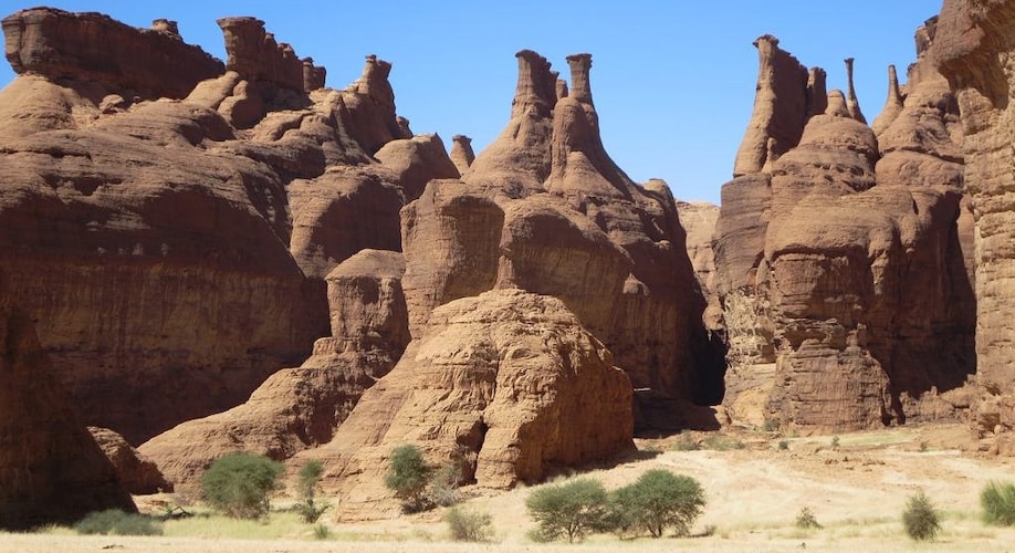
The dominant physical structure in Chad is a wide basin bounded to the north and east by the Ennedi Plateau and Tibesti Mountains, which include Emi Koussi, a dormant volcano that reaches 11,201 feet above sea level. Lake Chad, which takes its name from the Kanuri word for ‘lake’, is the remains of an immense lake that occupied 330,000 km2 of the Chad Basin 7,000 years ago. Although in the 21st century it covers less than 18,000 km2 and its surface area is subject to heavy seasonal fluctuations.
Ennedi Mountains – ©David Stanley CC BY 2.0 via Wikimedia Commons
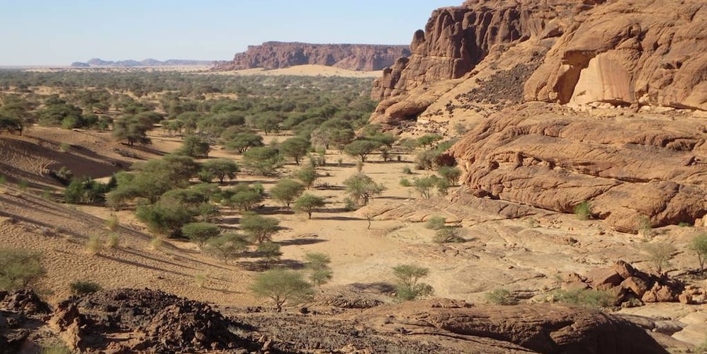
The country has six terrestrial eco-regions: East Sudanian savanna, Sahelian Acacia savanna, Lake Chad flooded savanna, East Saharan montane xeric woodlands, South Saharan steppe and woodlands, and Tibesti-Jebel Uweinat montane xeric woodlands. The region’s tall grasses and extensive marshes make it favourable for birds, reptiles, and large mammals. Chad’s major rivers; the Chari, Logone and their tributaries, flow through the southern savannas from the southeast into Lake Chad.
Each year a tropical weather system known as the intertropical front crosses Chad from south to north, bringing a wet season that lasts from May to October in the south, and from June to September in the Sahel. Variations in local rainfall create three major geographical zones. The Sahara lies in the country’s northern third. Yearly precipitations throughout this belt are under two inches; only occasional spontaneous palm groves survive, all of them south of the Tropic of Cancer. The Sahara gives way to a Sahelian belt in Chad’s centre; precipitation there varies from less than 12 inches to more than 23 inches per year. In the Sahel, a steppe of thorny bushes (mostly acacias) gradually gives way to the south to East Sudanian savanna in Chad’s Sudanese zone. Yearly rainfall in this belt is more than 35 inches.
Over 80% of Chad’s population relies on subsistence farming and livestock raising for its livelihood. The crops grown and the locations of herds are determined by the local climate. In the southernmost 10 percent of the territory lies the nation’s most fertile cropland, with rich yields of sorghum and millet.
Sahel Acacia Trees – ©David Stanley CC BY 2.0 via Wikimedia Commons
In the Sahel only the hardier varieties of millet grow, and these with much lower yields than in the south. On the other hand, the Sahel is ideal pastureland for large herds of commercial cattle and for goats, sheep, donkeys and horses. The Sahara’s scattered oases support only some dates and legumes. Before the development of oil industry, cotton dominated industry and the labour market and accounted for approximately 80% of export earnings.
Birding Chad
Chad’s animal and plant life correspond to the three climatic zones. In the Saharan region, the only flora is the date-palm groves of the oasis. Palms and acacia trees grow in the Sahelian region. The southern, or Sudanic, zone consists of broad grasslands or prairies suitable for grazing. There are 134 species of mammals, 600 species of birds (c.354 species are residents), and over 1,600 species of plants throughout the country.
Zakouma National Park – ©inyathi CC BY-SA 2.0 via Wikimedia Commons
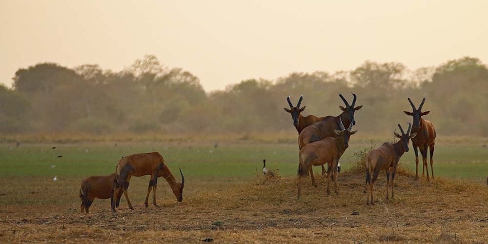
Elephants, lions, buffalo, hippopotamuses, rhinoceroses, giraffes, antelopes, leopards, cheetahs, hyenas, and many species of snakes are found there, although most large carnivore populations have been drastically reduced since the early 20th century. Elephant poaching, particularly in the south of the country in areas such as Zakouma National Park, is a severe problem. The small group of surviving West African crocodiles in the Ennedi Plateau represents one of the last colonies known in the Sahara today.
Only 3% of Chad is forested and all of that is publicly owned. Extensive deforestation has resulted in loss of trees such as acacias, baobab, dates and palm trees. This has also caused loss of natural habitat for wild animals; one of the main reasons for this is also hunting and livestock farming by increasing human settlements. Populations of animals like lions, leopards and rhino have fallen significantly. Efforts have been made to improve relations between farmers, agro-pastoralists and pastoralists in the Zakouma National Park (ZNP), Siniaka-Minia, and Aouk Reserve in southeastern Chad to promote sustainable development. As part of the national conservation effort, more than 1.2 million trees have been replanted to check the advancement of the desert, which incidentally also helps the local economy by way of financial return from acacia trees, which produce gum arabic, and also from fruit trees.
Poaching remains a serious problem in the country, particularly of elephants for the profitable ivory industry and a threat to lives of rangers even in the national parks such as Zakouma. Elephants are often massacred in herds in and around the parks by organised poaching. The problem is worsened by the fact that the parks are understaffed and that a number of wardens have been murdered by poachers.
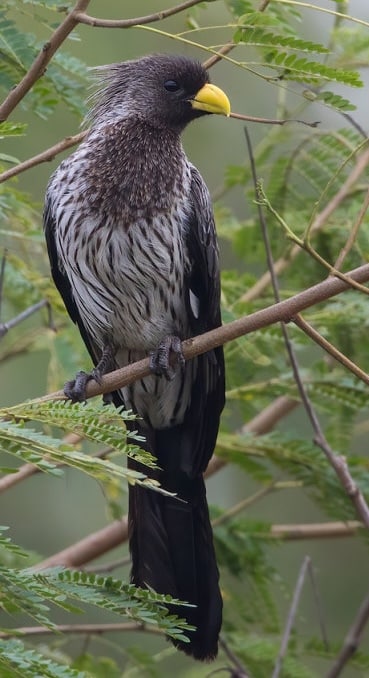
Sought-after birds found in Chad include Red-pate Cisticola, Chad & Reichenow’s Firefinch, Nubian Bustard, Rusty Bushlark, Kordofan Sparrow, Black-crowned Crane, Cream-coloured Courser and Stone Partridge.
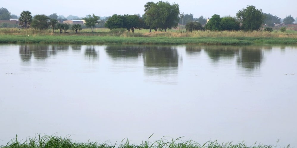
Chari River, N’Djamena – ©David Stanley CC BY 2.0 via Wikimedia Commons
Top birding sites include: Ouadi Rimé-Ouadi Achim Faunal Reserve, N’Djamena (Chari River), Zakouma National Park, Bahr Salamat Faunal Reserve, Sena Oura National Park and Binder-Léré Faunal Reserve – see Top Sites below.
Other good birding places include Siniaka-Minia National Park, Goz-Beida National Park, Abou Telfane Faunal Reserve, Tibesti Mountains, Lake Chad and Lake Fitri.
-
Aouk National Park
Aouk NP is great for for Violet Turaco, Blue-breasted Kingfisher, Golden-tailed Woodpecker, Red-headed Lovebird, Yellow-gorgeted Greenbul, Grey Tit-Flycatcher and Spectacled Weaver in particular. -
N’Djamena
N’Djamena (Chari River) is particularly good for River Prinia and Egyptian Plover among other waterbirds including White-faced Whistling Duck, Fulvous Whistling Duck, Allen’s Gallinule, Black Crake, Black-winged Stilt, Spur-winged Lapwing, Greater Painted-snipe, African Jacana, Gull-billed Tern, African Openbill, Reed Cormorant, African Sacred Ibis, Little Bittern, etc. -
Ouadi Rimé-Ouadi Achim Faunal Reserve
Ouadi Rimé-Ouadi Achim Faunal Reserve and Ennedi Massif (Fada Archei Faunal Reserve) which are good for Nubian Bustard among other desert or arid savanna species including Stone Partridge, Barbary Partridge, Egyptian Nightjar, Golden Nightjar, Mottled Swift, Pallid Swift, Arabian Bustard, Jacobin Cuckoo, Chestnut-bellied Sandgrouse, Spotted Sandgrouse, Crowned Sandgrouse, Lichtenstein’s Sandgrouse, etc. -
Southwest
South-west (Sena Oura NP, Zah Soo NP/Binder-Léré Faunal Reserve and Manda NP) is good for Niam-niam Parrot and Chad Firefinch as well as Double-spurred Spurfowl, Western Plantain-eater, White-crested Turaco, Levaillant’s Cuckoo, Klaas’s Cuckoo, Black Cuckoo, Red-chested Cuckoo, Adamawa Turtle Dove, Red-eyed Dove, Blue-spotted Wood Dove, Ovambo Sparrowhawk, Eurasian Hoopoe (waibeli), Purple Roller, Blue-bellied Roller, Broad-billed Roller, Bearded Barbet, etc. -
Zakouma National Park
Zakouma National Park (NP) and Bahr Salamat Faunal Reserve is excellent for Common Ostrich, Helmeted Guineafowl, Clapperton’s Spurfowl, Long-tailed Nightjar, White-rumped Swift, Black-bellied Bustard, Great Spotted Cuckoo, Diederik Cuckoo, African Cuckoo, Four-banded Sandgrouse, Vinaceous Dove, Black-billed Wood Dove, Bruce’s Green Pigeon, Black Crowned Crane, Spotted Thick-knee, Bronze-winged Courser and many more.
-
Wikipedia
GNU Free Documentation License
https://en.wikipedia.org/wiki/Chad
-
Number of bird species: 604
(As at February 2025)
-
Avibase
PDF ChecklistThis checklist includes all bird species found in Chad , based on the best information available at this time. It is based on a wide variety of sources that I collated over many years. I am pleased to offer these checklists as a service to birdwatchers. If you find any error, please do not hesitate to report them. -
E-Bird
PDF ChecklistThis checklist is generated with data from eBird (ebird.org), a global database of bird sightings from birders like you. If you enjoy this checklist, please consider contributing your sightings to eBird. It is 100% free to take part, and your observations will help support birders, researchers, and conservationists worldwide. -
Wikipedia
Annotated ListThis is a list of the bird species recorded in Chad. The avifauna of Chad include a total of 602 species.

Birds of Africa
Apple iOS | AndroidBirds of Africa was developed as an aid to conservation and is an asset of The African Bird Club. It is a guide to more than 2300 species of birds in 43 countries... Birds of Africa – an identification guide which in time will cover all the birds and countries in Africa. The latest version of this app is available to download for free from the App Store or Google Play.Organisations-
African Bird Club
WebsiteAfter decades of civil war and with limited tourist infrastructure, it is not surprising that there are few ornithological records from Chad in recent years. However, with a bird list of over 500 species including Schlegel -
West African Ornithological Society
WebsiteThe West African Ornithological Society grew out of the Nigerian Ornithologists
Reserves-
*Protected areas of Chad
InformationSatellite ViewInteractive links to National Parks, Ramsar sites etc. -
FR Binder-Léré Faunal Reserve
InformationSatellite ViewBinder-Léré Faunal Reserve, in south-west Chad, bordering Cameroon, was established in 1974, covering an area of 1,350 km2 (520 sq mi). It has been designated as a Ramsar site since 2005. -
FR Ouadi Rimé-Ouadi Achim Faunal Reserve
InformationSatellite ViewThe Ouadi Rimé–Ouadi Achim, covering three habitats of Sahelian wooded grassland, sub-desert grassland (covers about 66% of the area), and desert, and is one of the largest reserves in Chad... -
NP Manda
InformationSatellite ViewManda NP occupies a total area of 440 square miles. Prior to its elevation as a national park, Manda was strictly a faunal reserve. Manda National Park is rich in birds’ species including Yellow penduline, white collared Starling, and Bush petronia. -
NP Zakouma
InformationSatellite ViewZakouma National Park is a 1,158-square-mile (3,000 km2) national park in southeastern Chad's Salamat Region. Zakouma is the nation's oldest national park. Birds include ostriches, cranes, eagles, egrets, herons, ibis, pelicans, and storks. Special species include Abyssinian ground hornbills, black-breasted barbets, northern carmine bee-eaters, and red-billed queleas. -
WII Bahr Aouk River
InformationSatellite ViewThe Bahr Aouk meets the Chari River, which leaves the border and flows north into the Chad. -
WII Lac Fitri
InformationSatellite ViewSimilarly to Chad's other lake, Lake Chad, it is not quite as large as once was. It has been designated under the Ramsar Convention as a Wetland of International Importance. -
WII Lake Chad
InformationSatellite ViewThere are many floating islands in the lake. It is home to a wide variety of wildlife, including elephants, hippopotamus, crocodile (all in decline), and large communities of migrating birds including wintering ducks, ruff (Philomachus pugnax) and other waterfowl and shore birds. There are two near-endemic birds in the region, the river prinia (Prinia fluviatilis) and the rusty lark (Mirafra rufa). The shrinking of the lake is threatening nesting sites of the black-crowned crane (Balearica pavonina pavonina).
Sightings, News & Forums-
eBird
SightingseBirding This Month
Trip Reports-
2022 [04 April]- Royle Safaris
ReportZakouma NP is now very much an open secret. For years, it was thought that the savanna reserves of Western and Central Africa could simply not hold a candle to the famous parks further east and south, but it is now clear that Zakouma is an exception to that rule. Boasting hugely impressive densities of both mammals and birdlife, particularly around Rigueik Pan, as well as some of the most consistently productive night drives on the continent, Zakouma is a superb example of conservation done right thanks to the stewardship of African Parks. -
2023 [03 March]- Royle Safaris
ReportWe also recorded a hugely impressive 273 species of birds including new records for the country for several species including one of Africa’s most impressive birds, the Crowned Eagle
-
Fatbirder - linking birders worldwide...
Skip to content